AccuNav NTRIP-GNSS
High-accuracy PPP-RTK corrections delivered through standard NTRIP connections.
AccuNav NTRIP-GNSS
Overview
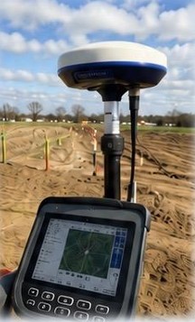
AccuNav NTRIP-GNSS Corrections provide real-time PPP-RTK correction data for GNSS receivers requiring centimeter-level positioning accuracy.
Delivered through standard NTRIP connections, AccuNav works with many modern GNSS receivers and can be used over cellular, Wi-Fi, Starlink, and other internet-connected networks.
Unlike traditional local base station RTK workflows, AccuNav provides wide-area PPP-RTK coverage without dead spots between bases and without the need to manage local base station infrastructure.
AccuNav is ideal for surveying, mapping, construction, machine control, seismic operations, agriculture, GIS, and other precision positioning applications.
Features
- Supports sub-meter and centimeter-level GNSS positioning
- PPP-RTK correction service
- Improves receiver accuracy and recovery
- Typical AccuNav PPP-RTK accuracy: 3–6 centimeters
- Delivered through standard NTRIP protocol
- Reliable real-time correction delivery over the internet
- Works over cellular networks
- Works over Wi-Fi and fixed internet
- Works over Starlink internet connections
- Coverage across the United States
- Coverage in southern Canada
- Coverage in western Europe
- Coverage in parts of Australia, South Korea, and Japan
- No dead spots between local base stations
- Compatible with Trimble receivers
- Compatible with Topcon receivers
- Compatible with Leica receivers
- Compatible with Septentrio receivers
- Compatible with Hemisphere GNSS receivers
- Compatible with ComNav receivers
- Compatible with Carlson GNSS systems
- Compatible with Emlid receivers
- Compatible with Seismic Source GNSS solutions
- Supports many other NTRIP-compatible receivers
- Seismic surveying
- Surveying and mapping
- Construction layout
- Machine control
- Utility mapping
- GIS data collection
- Agriculture guidance
- Drone mapping
- Environmental monitoring
- Infrastructure inspection
Benefits
- AccuNav improves GNSS positioning accuracy for applications requiring precise location data.
- Wide-area PPP-RTK corrections reduce or eliminate the need to set up and manage a local RTK base station.
- Crews can connect through standard NTRIP and begin receiving corrections without manual base station setup.
- NEAR stream technology helps avoid manual mountpoint changes across large project areas.
- AccuNav works with many existing NTRIP-compatible GNSS receivers and field controllers.
- No local base station, no usage-based fees, and flat-rate monthly or annual plans help reduce project infrastructure cost.
- Crews can connect using cellular, Wi-Fi, Starlink, or other internet-connected networks depending on the project location.
Brochure
AccuNav NTRIP-GNSS BrochureRelated Applications
AccuNav is used anywhere high-accuracy GNSS corrections are required over internet-connected networks.
- High-accuracy positioning for seismic acquisition, receiver layout, source points, and field navigation.
- Centimeter-level positioning for survey and mapping projects.
- Reliable positioning for machine control and automation.
- Precision guidance and asset tracking for agriculture operations.
- Accurate field location data for GIS collection, utility mapping, and infrastructure records.