NodeLink
Field assistant software for node deployment and receiver station navigation.
NodeLink
Overview
NodeLink is a GPS-enabled Android tablet application designed to streamline nodal receiver deployment and improve field productivity. The system guides technicians to receiver locations, tracks deployed nodes, records deployment information, and integrates directly with SourceLink production management software.
Prior to deployment, the observer creates a project in SourceLink that includes maps, receiver station preplots, exclusion zones, and known hazards. The project is then distributed to Android tablets used by deployment crews in the field.
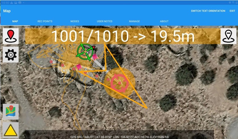
During deployment, technicians navigate directly to receiver stations, deploy nodes, scan equipment, acknowledge installations, and proceed to the next location. Deployment information is collected automatically and later imported back into SourceLink for production tracking and reporting.
Features
- Android tablet based deployment system
- Integrated GPS navigation
- Navigate directly to receiver stations
- Real-time distance and direction guidance
- Supports large-scale nodal deployments
- Projects created within SourceLink
- Receiver station preplots
- Surface maps
- Exclusion zones
- Hazard identification and mapping
- Node scanning and registration
- Deployment confirmation
- Technician deployment logs
- Automatic location tracking
- Deployment status management
- Direct integration with SourceLink
- Imports deployment logs
- Updates SourceLink database
- Production reporting support
- Crew activity tracking
- Supports most nodal manufacturers
- Android tablet platform
- GPS-enabled operation
- Large crew deployments
Benefits
- GPS-guided navigation reduces time spent locating receiver stations and increases deployment efficiency.
- Technicians are guided directly to planned receiver locations, helping ensure accurate node placement.
- Node scanning and deployment confirmation create a digital record of field activity.
- Preloaded maps, hazards, and station locations simplify field operations and reduce confusion.
- Deployment logs are automatically imported into SourceLink, reducing manual data entry.
- Observers receive accurate deployment records that feed directly into production reports.
Brochure
NodeLink BrochureRelated Applications
Learn more about applications commonly used with this product.
- GPS-guided receiver placement for large nodal crews.
- Improve productivity and accuracy during receiver deployment projects.
- Connect deployment activities directly to SourceLink production management.
- Guide technicians using maps, station preplots, hazards, and exclusion zones.
- Automatically import deployment information into daily production reports.